Program Science
The Fatima science plan encapsulates three main components:
- Fatima-F - Field Campaigns
- Fatima-M - Numerical Simulations using NWP as well high-resolution models
- Fatima-T - Technology Development
Laboratory experiments will be conducted when needed to delve into new field-observed phenomena, permitting time and personnel availability
Fatima-F: Field Campaigns
Three field campaigns of varying complexity are planned, two MSF campaigns in the Grand Banks (GB) and Yellow Sea (YS) during the base period and an Ice Fog (IF) campaign during the option period.
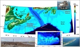
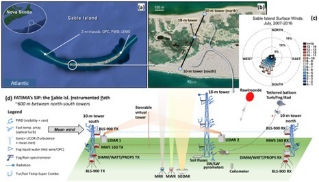
Grand Banks Campaign (2022 July): This involves extensive measurements aboard an R/V and on a small Atlantic Island (Sable Island) belonging to the Parks Canada Services. Measurements from Hibernia Oil Platform are also expected in collaboration with Wood IS (Fig. 1a). The Sable Island layout is given in Fig 2.
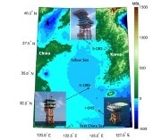
Yellow Sea Campaign (2023 June): This is a ship (R/V) based campaign in collaboration with Korea Institute of Ocean Science and Technology (KIOST). Additional meteorological and visibility data will be provided by KIOST platforms (Fig. 1b).
Ice-Fog Campaign (2025 February, ~3-4 weeks): This is expected to be at the Department of Energy, Atmospheric Radiation Measurement (ARM) scientific-user facility in Barrow, AK, known as the North Slope of Alaska (NSA) site on the coastal Arctic. NSA facilitates cloud and aerosol observations at high latitudes.
Ship-Based Campaigns:
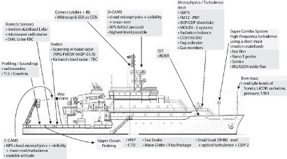
The instrumentation on the R/V for both GB and YS campaigns is depicted in Fig. 3. Our siting strategy enables:
- Comprehensive characterization of visiblity, general meteorology, turbulence, upper-ocean, and ocean-surface properties akin to fog lifecycle;
- High-resolution vertical profiling of dynamic, thermodynamic and microphysical properties of Marine Atmospheric Boundary Layer with/without fog; and
- Investigations on optical propagation in foggy turbulent atmosphere.
Other Platforms:
During the GB campaign, Wood IS plans to deploy a Metocean buoy in the Hibernia platform exclusion zone, in the open sea. Wood requests that a MWR and a Lidar be deployed by Fatima group on the Hibernia Platform itself to obtain data over a larger area. During the YS study, meteorological, visibility and oceanic data taken by KIOST platforms will be available. These platforms have extensive instrumentation, which will be augmented as permitted. Hundreds of hours of visibility and wind data are already available from Hibernia and KIOST, but care must be taken to exclude periods of platform interference.
Fatima-M: Modeling and Simulations
Modeling and simulations are co-equal tasks in Fatima, alongside field experimentation. They elicit fundamental dynamics via theoretical analysis, help process studies through high resolution simulations, provide fog forecasts based on NWP models, aid data interpretation, identify model deficiencies, and help develop better parameterizations..
NWP Model Simulations: We will mainly employ WRF-ARW and COAMPS® platforms, first in forecasting mode to help IOP decisions, followed by higher resolution hindcasting mode for process studies. This approach was successfully used in C-FOG field study.
Fatima collaborators are currently using WRF/PAFOG and COAWST/PAFOG models for YS fog. COAWST is a Coupled [Ocean (ROMS)/Atmosphere (WRF)/Wave (SWAN)/Community Sediment Transport] modeling system, and PFOG is a 1-D fog model for low-level stratiform and radiation fog. They will use COAWST/PAFOG at 2-km horizontal resolution to understand the roles of turbulence and sharp change of SST on the fog lifecycle.
Direct Numerical Simulations (DNS): Delineation of small-scale processes of MSF requires resolved simulation of air-sea interactions while rationally accounting for fog microphysics (since resolving microphysics at ~ 0.1 μm scales is infeasible). At the air-sea interface, wave breaking and sea spray are key processes affecting momentum and sensible/latent heat exchange. We will perform DNS of air and water mixed flows at small scales to directly capture relevant processes impacting fog dynamics. MSF conditions.
Large Eddy Simulations (LES): In parallel, LES approach with fog microphysical processes represented by “bulk” schemes of mesoscale models (e.g., one/two moment schemes) will be employed as a direct test bed for isolating and understanding the role of turbulence in fog lifecycle and interpret observational data [e.g., LES mode of CM1 model]. Typical ABL processes can be resolved by this ‘bulk’ method.
Satellite Retrieval of Fog: We will refine and validate fog detection algorithms based on the Geostationary Ocean Color Imager GOCI (by Park/KIOST) and GOES-16 (by Gultepe; see Gultepe et al. 2007b). GOCI produces daytime imagery every hour at 500 m resolution and is being used to differentiate fog/no-fog periods using a decision-tree approach (Kim et al. 2020b) and develop fog microphysical-parameter discrimination algorithms (Pavolonis 2010; Gultepe et al. 2021b). Fatima data will help reduce the false alarm rate of these algorithms.
Fatima-T: Technology Development
Probing Kolmogorov scales requires measurements of velocity, temperature T and moisture simultaneously at very high resolutions. During MATERHORN MURI, a novel (‘Combo’) system was developed for measurement of the turbulent kinetic energy dissipation rate. The Combo has a hotfilm on a gimbal, informed by a co-located sonic anemometer and a neural network to align hotfilm with the wind direction (a technical requirement). We will integrate the latest fast response T (nano-probe) and moisture sensing technologies to develop the ‘Super Combo’. We plan for a low-cost (~$150/sensor) hotwire liquid water content (LWC) probe based on the King probe design are afoot.
We will continue the development of a portable fog characterization device (FCD). Here the probe volume will be illuminated by white, green and near-IR sources and the receivers will capture attenuated IR beam and scattered visible light. The droplet sizes and local velocities will be measured by illuminating a nearby slice of the atmosphere using a green laser sheet and capturing illuminated fog droplets using an ultra-high resolution (20MPixel/18fps) FLIR Blackfly model=BFS-U3-200S6C-C color camera through a telescopic lens. The fog droplets usually are reasonably well separated, and hence the interference between disparate droplets during image analysis is small. Initial tests allowed resolution of droplet sizes great than 1 micron by assuming lateral homogeneity (this is similar to Phase Doppler Anemometry used for single-point droplet and velocity measurements, but allows whole field fog interrogations). An increase of beam length to ~ 1m will allow capturing the lower end of inertial subrange, and hence versatile extrapolation of result to the atmosphere.